


After we arrived in Puerto Vallarta, we had problem: where should we go next? We had a huge list of cities we wanted to visit in Mexico, but we weren’t sure what the best route would be.
Turns out, this is a problem that I studied back in school. In computer science, it is known as the Traveling Salesman Problem. To state it specifically: given a list of cities and distances between them, what is the shortest route through those cities?
We had a list of cities, but I wasn’t sure of the distances between them. Luckily, some glorious hackers have mashed google maps to give you solutions to this type of problem! We ended up using OptiMap to help us figure out a route.
In order to do this, first make a list of cities. Here is what our list looked like:
Puerto Vallarta, JAL, Mexico
Guadalajara, JAL, Mexico
Melaque, JAL, Mexico
La Ticla Aquila, MICH, Mexico
Ixtapa, Guerrero, Mexico
Morelia, MICH, Mexico
Guanajuato, GTO, Mexico
San Luis Potosi, Mexico
Tequila, JAL, Mexico
Mexico City, Federal District, Mexico
Oaxaca, Mexico
Playa Zipolite, Mexico
San Jose Manialtepec, OAX, Mexico
Tlaquepaque, JAL, Mexico
San Miguel de Allende, GTO, Mexico
Mineral de Angangueo, MICH, Mexico
San Agustinillo, Oaxaca, Mexico
Xilitla, SLP, Mexico
Puebla, Mexico
Taxco, Guerrero, Mexico
Pátzcuaro, Mexico
Palenque, Chiapas, Mexico
Merida, Yucatan, Mexico
San Cristóbal de Las Casas, CHIS, Mexico
Zacatecas, ZAC, Mexico
Chetumal, QROO, Mexico
How did we come up with this list? Well, Erica has been reading travel magazines, blogs, and websites for years. She keeps a scrap book of all the places she wants to visit. Some of the places couldn’t be found by Google, so instead we just tried to pick cities that were nearby.
Next, head over to OptiMap and click the “Bulk add by address” link. This will pop up a text area where you can paste in all the cities you want to visit. When you are done click “Add list of locations”.
It will take a few minutes, but it should plot out a map showing all the locations you just entered. It should look something like this:
The list of cities we wanted to visit, plotted on a Google Map.
Now, you may need to give OptiMap a few hints about your route. Specifically, we were in Puerto Vallarta, so we clicked on Puerto Vallarta on the map and set it as our starting location:

In addition, we clicked on Chetumal and set it as our ending location:

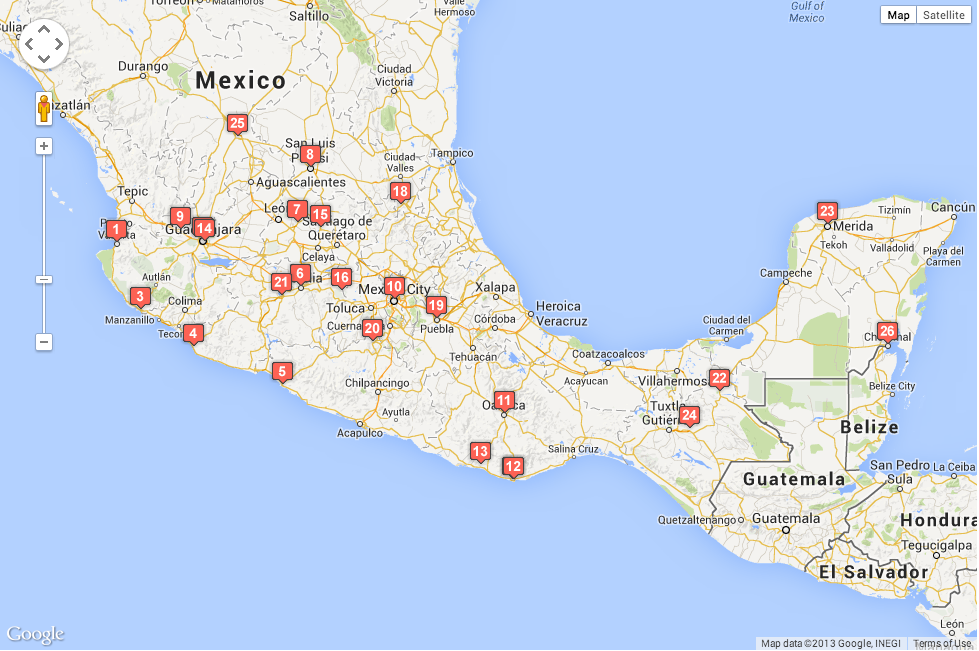
Now you are almost done! Just click the “Calculate Fastest A-Z Trip”. It will take it a while, but eventually it will spit out a map. Here’s what ours looked like:
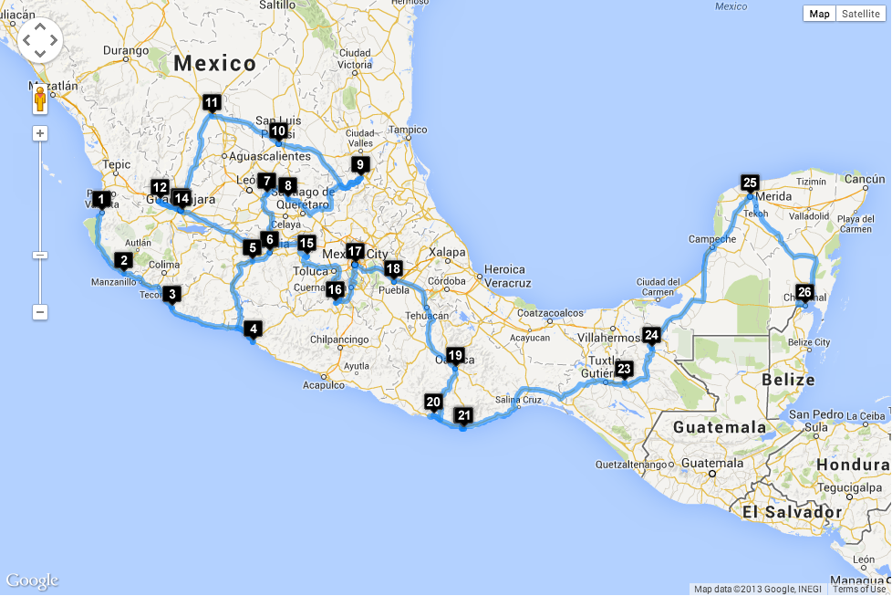
A suggested route through Mexico — this was a great help to us in our planning.
We won’t follow this route exactly. In fact, we’ve already veered off this route, but overall it has been a very helpful guide to us.
Unfortunately, tools like this won’t work in places where there aren’t good maps. Google does fine in Mexico, but it seems to have more difficulty in central and south america. Hopefully our routes through central and south america will be more straight forward–there was just so much we wanted to see in Mexico, we needed some help — and OptiMap provided it.
Have you used other tools to help plan routes on trips? We’d love to hear about them — leave us a comment!